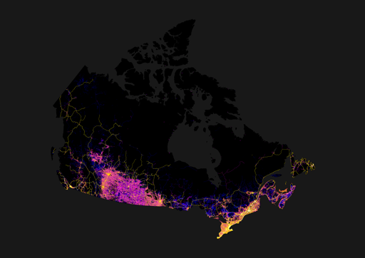
Roads in Canada (lifted from imgur)
-
Some of it’s actually rail and not roads—I’m pretty sure that one line running up to the bottom of James Bay is actually the Polar Bear Express’ tracks for at least part of its length. Some may also be clearance for seasonal (ice) roads, or high-tension power lines. And yeah, some of it’s probably logging.
Some of it’s actually rail and not roads
Such as the more northerly line running east from Winnipeg.
-
Its a good seperatation for political purposes
Until the mid '90s, the map on the wall in the public area at Queens Park was cropped off just west of Sudbury.
Something my friends in Thunder Bay found indicitave of the level of attention and support they got from the provincial government
It would honestly be reasonable for northern and southern Ontario to decide on a line and be managed seperately, if not become their own provinces. The gta takes too much of the provincial focus sometimes. Just look at ford’s temper tantrum over torontos bike lanes, the province as a whole has much bigger issues he should be addressing.
-
Which part? The southern prairie has ‘grid’ roads (magenta; literally roads in a grid, every mile E/W, every two N/S), with highways connecting the many towns and cities, settled because of agriculture. Then the northern shield (forest) has roads where they fit best to mainly indigenous communities.
If you look at Alberta and Manitoba, they also have the grid roads, but just looks more connected with a grid of highways following N/S or E/W. Saskatchewan’s highway system reminds me of nerve cells reaching out with all the angled highways spreading out from the cities.
-
Eh. I read it as BC not getting much funding for infrastructure from the feds, coupled with copious issues with development and treaties. BC’s population is overly concentrated in the GVRD, with almost half the provinces people living there. Part of the reason being the lack of infrastructure / job opportunities in other regions.
I celebrate all of those things. Hopefully we perform as few highway expansion projects as possible and focus on rail instead. Also hopefully BC’s population remain concentrated in metro Vancouver so we preserve as much wilderness as possible instead of sprawling endlessly.
-
I don’t read this as Vancouver being isolated, I just read this as the prairies being victims/perpetrators of car dependent sprawl.
With a shit ton of complex geography, of course traffic is going to concentrate on a few main highways/roads
The mountains keep Vancouver sprawl in check
-
But wouldn’t farmed land increase if there is an abundance of oil? Needed for farming equipments.
Actually, most of the ground would have originally been broken using literal horsepower, which runs on hay rather than oil. Tractors didn’t become the norm until after WWI (maybe not even until after WWII, I’m not an expert on agricultural history, but I do know that the reason you used to see wooden grain elevators every few kilometers along prairie railways was to accommodate farmers who were still hauling stuff in horse-drawn wagons). By the time the oil was being commercially exploited, most of the useful land was already under the plow.
This is pretty much the case. I farm in an area that was homesteaded late for most of the prairies (early 1900s), and that was all done with horses. I have an uncle that just recently passed away that was part of the transition to mechanical power, and their first tractor was gas-powered one since it would start in the cold. That would have been about WW2 time since he was a teenager when it showed up and they got rid of the draft horses.
-
Google reverse image search shows this as the original source: https://imgur.com/map-roads-of-canada-w7lDes8
You can see the bit northeast of Thunder Bay where there is only one single major road connecting the entire East and the entire West.
-
The mountains keep Vancouver sprawl in check
They kind of don’t. The sprawl of the metro van region happens in Surrey, Langley etc.
-
You can see the bit northeast of Thunder Bay where there is only one single major road connecting the entire East and the entire West.
Crazy how the whole northeast of Winnipeg is mostly dead.
I always found it funny driving through Thunder Bay to Winnipeg that it was called “northern Ontario” when you’re following the US border and landing squarely in southern Manitoba.
-
Google reverse image search shows this as the original source: https://imgur.com/map-roads-of-canada-w7lDes8
Canada’s shape looks kind of like a shark
-
You can see the bit northeast of Thunder Bay where there is only one single major road connecting the entire East and the entire West.
Manitoba should invade down that highway – see how the rest of Canada feels when the Riel Rebellion …
Ah nevermind, let bygones be bygones.